On 4 September 2026, the United Nations General Assembly adopted a non-binding resolution that might initially appear to belong to the relatively technical world of cartography. The resolution, “Correct the Map: Rebalancing Global Cartographic Representation and Promoting Equitable Representation of the World’s Regions, Particularly Africa,” was introduced by Togo on behalf of the African Group and adopted by 164 countries, with one country voting against and six abstaining.
In presenting the resolution, Togo’s Foreign Minister Robert Dussey argued that maps are not merely technical tools: their repeated use in schools, the media and digital platforms shapes how people understand and visualise the world. The African Group argued that the Mercator projection, designed for specific purposes—especially maritime navigation—had become a general-purpose image of the world that visually minimises Africa and other regions near the Equator.
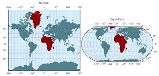
The delegation framed the initiative around scientific and educational accuracy, cognitive justice, historical memory and the equal dignity of peoples. It also stressed what the resolution would not do: condemn the Mercator projection, impose a single map for every use, alter borders or take a position on territorial claims. Instead, it encouraged the use of projections such as Equal Earth when comparing the relative areas of continents, alongside better teaching about the strengths and limitations of different projections.
The resolution encourages the use of equal-area map projections, including Equal Earth, particularly when the relative size of regions matters. It also highlights the implications of existing representations for geographical and cartographic literacy. Importantly, however, it does not replace the Mercator projection, redraw international borders or alter the legal status of any territory. So why does a map matter? And why now?
These questions are more significant than the technical debate over which projection should be used. The UN resolution opens a much larger question about who has historically possessed the authority to represent the world, whose knowledge becomes universal knowledge, and what happens when previously marginalised actors begin to challenge that authority.

The map is not the territory—but it shapes how the territory is imagined
Gerardus Mercator’s famous projection was first published in 1569. It was developed primarily as a tool for maritime navigation, as its preservation of angles and constant compass bearings made it particularly useful for sailors plotting routes across oceans. The projection was never intended to provide an accurate comparison of the relative size of continents. Its distortion, however, has had a long afterlife.
Because the Mercator projection increasingly enlarges landmasses as they move away from the Equator, Greenland can appear comparable in size to Africa, despite Africa being approximately fourteen times larger.There is therefore an important distinction to make. Mercator was not invented as a deliberate attempt to make Africa smaller. Its original purpose was navigational. The political question emerges from what happened afterwards: how a projection designed for a particular technical purpose became normalised as a general image of the world.
A cartographic choice made for navigation became, through repetition, an educational and cultural convention. Maps entered classrooms, atlases, newspapers, television graphics, websites and digital platforms. In doing so, they did more than provide geographical information. They participated in producing a particular visual imagination of the world. This is where cartography becomes political. Can a two-dimensional map ever be neutral?
From geographical distortion to cognitive hierarchy
The significance of the new UN resolution therefore lies less in replacing one map with another than in recognising that representation itself has consequences. The resolution’s language is striking. It connects cartographic representation to education, perception and collective understanding, framing the correction of historical distortions as a matter of equitable representation. The UN Office of the Special Adviser on Africa has presented the initiative as an African-led effort to challenge the symbolic minimisation of the continent. But the tension remains.
If representation contributes to how societies imagine the world, then correcting representation can be understood as a form of cognitive or epistemic intervention. Yet cognitive correction is not the same thing as material transformation. Africa does not become politically more powerful because it appears larger on a classroom wall. Its borders do not change. Its economies do not automatically become less dependent on external capital. Its resources do not cease to be sites of extraction. Conflicts do not become more visible merely because the continent is represented more proportionately. This is precisely where the politics of the map becomes interesting. What does it mean to correct the image of Africa while leaving many of the structures that have historically shaped Africa’s position in the international system intact?
Why Africa, and why now?
The timing of the resolution is important. It comes amid a broader period in which African states have increasingly sought greater authority over how African histories, identities and political interests are represented internationally. In March 2026, for example, Ghana led a separate UN initiative recognising the transatlantic trafficking of enslaved Africans and racialised chattel enslavement as the “gravest crime against humanity”. That resolution was adopted by 123 votes to three, with 52 abstentions.
These initiatives are different in substance. One concerns historical enslavement; the other concerns cartographic representation. Yet they can be read together as part of a broader struggle over who gets to define historical knowledge and the terms of recognition within international institutions. This is not simply a demand to be represented more accurately. It is also a demand to participate in determining what counts as accuracy. That distinction matters.
For centuries, knowledge about Africa was frequently produced through institutions, categories and intellectual frameworks located outside the continent. Colonial cartography did not merely describe territories; it participated in ordering them. Colonial knowledge systems classified populations, territories and resources in ways that made them legible to imperial administration.
The contemporary map is not identical to the colonial map. Nor should Mercator’s projection itself be treated as a colonial conspiracy. But the history of mapping reminds us that knowledge and power have rarely been entirely separate.The question today is therefore not simply whether Africa has been drawn at the wrong scale. It is whether Africa is increasingly claiming the authority to participate in drawing the conceptual map of the world.
The paradox of symbolic recognition
Here lies the deeper paradox. The international system can recognise that Africa has been visually underrepresented while continuing to struggle with the structural inequalities that shape Africa’s position within that same system. The map can be corrected much more easily than the hierarchy. A classroom can replace one projection with another in an afternoon. Changing the global distribution of economic power, institutional representation and access to capital—and changing who controls natural resources or sets the terms of international decision-making—is considerably more difficult. I describe this gap as moral fragmentation.
By moral fragmentation, I mean a condition in which international actors can converge around the recognition of a particular historical or representational injustice while remaining divided—or unwilling to act collectively—on the deeper structures through which inequality is reproduced. The map provides a particularly revealing example. The African Union has also called for permanent African representation on the UN Security Council. This demand raises a related question: how should the continent’s political weight and interests be represented within global institutions?
There is now remarkably broad agreement that the relative size of Africa should not be visually distorted when size is what a map is intended to communicate. Yet there is no equivalent consensus about what a more equitable international political and economic order should look like. The correction of representation therefore raises an uncomfortable question: Can an international system correct the image of inequality without confronting the structures that produce inequality?
The politics of the classroom
The emphasis on education in the resolution deserves particular attention. The UN initiative is not only about producing a different image for diplomats or cartographers. It explicitly engages with educational and geographical literacy.
That matters because maps enter political consciousness long before most people encounter international relations as an academic discipline. Children learn the world through images. They learn which countries appear large, which appear small, which regions dominate the page, and which are visually peripheral. They learn spatial hierarchies before they necessarily have the vocabulary to question them.
This does not mean that seeing Africa at its correct relative scale automatically produces anti-racist or anti-colonial consciousness. That would be another form of determinism. But it does mean that representational choices form part of the environment in which political knowledge is produced. The classroom is therefore not politically neutral simply because the lesson is called geography.The question is not whether a map determines what a child thinks. It is whether repeated representations contribute to what becomes familiar, normal and imaginable.
The United States and the politics of disagreement
The vote itself adds another layer to the story. The United States was the only country to vote against the resolution, while Estonia, Georgia, Lithuania, Moldova, Serbia and Ukraine abstained. It would be tempting to interpret the American vote as evidence that Washington rejects the principle of more equitable representation of Africa. The vote alone, however, cannot establish that. The United States did offer an explicit explanation: its representative argued that the resolution formed part of what Washington characterised as a wider ideological project, pointing specifically to references to reparations and “cognitive justice”.
The US delegation described resolutions of this kind as distractions from issues it considered more directly connected to international peace, prosperity and good relations, and argued that they undermined the UN’s credibility. This provides evidence for interpreting the vote: the objection was not presented as a technical disagreement over the mathematics of map projections, but as opposition to the resolution’s wider political framing. It does not, however, establish every motive behind the vote or mean that the United States opposed all efforts to improve cartographic accuracy.
The contrast is revealing: Togo presented accurate representation as a matter of dignity and educational fairness, while the United States treated the resolution’s links to reparations and cognitive justice as evidence of ideological overreach. Several delegations supporting the resolution emphasised that it should not be understood as changing borders, sovereignty or territorial claims. Mexico, for example, supported the resolution while stressing that different projections serve different purposes and that no single projection can represent every property of the Earth without distortion.
This disagreement is important because it prevents the debate from becoming a simplistic opposition between a supposedly enlightened South and an obstructive North. Politics are more complicated.
The real question is not whether one map is universally “correct”. Every projection involves choices and compromises. The question is who gets to decide which compromises are appropriate, for which purposes, and whose historical experience informs those decisions.
From correcting the map to questioning the world it represents
Perhaps the most provocative aspect of the resolution is therefore not that Africa will appear larger. It is that an African-led initiative has successfully placed a seemingly technical question of cartography onto the agenda of the world’s principal multilateral institution. For a long time, Africa has frequently appeared in international discourse as an object of knowledge: a continent to be mapped, measured, developed, secured, rescued or extracted from. The “Correct the Map” initiative reverses that relationship, at least symbolically. Africa is not simply being represented; it is intervening in the politics of representation.
But symbolic intervention has limits. If the correction ends with a different image on the classroom wall, the transformation remains incomplete. The more difficult task is to ask what else must be corrected: whose knowledge is treated as authoritative, whose histories receive institutional recognition, who controls resources, who sets the terms of development, whose voices shape international institutions, and who gets to define what constitutes justice.
The danger is that the international system becomes very good at recognising injustice symbolically while becoming considerably less willing to redistribute power materially. That is the contradiction at the heart of the new map. A larger Africa on the map is not necessarily a more powerful Africa in the world. That is precisely why the map matters. The point of correcting it should not be to make Africa look bigger. It should be to make visible the question of why Africa has so often been made to matter less.
–
This article was first published by ROAPE.